
Page 211 -
P. 211
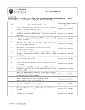
COURSE PRO FORMA


             IMPORTANT:
             Contents of this Pro Forma shall not be changed without the Senate’s approval for items indicated with *. Changes
             to the other items can be approved at the Academy/Faculty/Institution/Centre level.

                                                                                     References/Teaching Materials/
               Week                     Lecture/Tutorial/Assignment Topic
                                                                                             Equipment
                 1       Concept and Principles of GIS: Information Tecnology and Geographic   Reference books and notes
                         Information. Geographic Information System.
                         Geographic  Information  System,  definition,  components  of  GIS,
                 2
                         contributing  disciplines  and  technologies,  major  areas  of  practical   Reference books and notes
                         applications

                 3       Geographic  Data  Concepts:  Spatial  data  Models,  vector  vsraster, 3D   Reference books and notes
                         surface representation

                 4       ARC/INFO  Data  Models,  The  coverage,  Linking  Features  and   Reference books and notes
                         Attributes, Geographic database,
                 5       Feature types, point, arcs and polygons. Topology, arc-node   Reference books and notes
                         topology, polygon-arc topology.
                         Sources,  Collection  and  Integration  of  Data:  Digitising  Maps,
                 6
                         Surveying,  Photogrammetric  Mapping,  Remote  Sensing  Images,   Reference books and notes
                         Attribute data.

                 7
                         Sources of possible errors in GIS                          Reference books and notes

                 8       Software and Hardware: Hardware architecture of a GIS, Selection of   Reference books and notes
                         GIS software
                         Digital  Elevation  Model(DEM):  Important  use  of  DEMs.  Methods  of
                 9
                         representing  DEMs,  Data  sources  and  sampling  for  DEMs.  Product   Reference books and notes
                         derived from DEMs
                         Spatial data Manipulation and Analysis: Functional Spatial Analysis, 2
                 10
                         Dimensional,  Area,  perimter  and  distances.  Vector  to  Raster   Reference books and notes
                         conversion, Raster to vector conversion.

                 11      Analysis Overlays, Querying/Theming, Proximity analysis,
                                                                                    Reference books and notes
                         Network analysis. Contour lines and creating DEM
                 12
                         Application of GIS: Civil Engineering applications         Reference books and notes

                 13      Choosing a GIS. Criteria for a good GIS software, its functionality and   Reference books and notes
                         efficiency

                 14
                         The future of GIS in Malaysia                              Reference books and notes


               UM-PT01-PK03-BR003(BI)-S04